

Section I1
( Partisan Traverse )
I1 – Kapinovo – Skocivir 167.2km
Section I1 represents the heart of the Macedonian Endless Trail, traversing some of the country’s most remote and historically significant wilderness. This challenging multi-day trek follows ancient paths, crosses dramatic mountain ridges, and descends through river canyons carved over millennia. Named for the Partisan routes of World War II, this section connects forgotten villages, historic churches and monasteries, and landscapes largely unchanged for centuries.
Beginning at the center of the Macedonian Endless Trail in the depopulated village of Kapinovo, the route winds through the Mokrenska mountain, traverses the spine of Babuna Mountain with its sweeping 360-degree views, and ultimately descends into the wild Crna Reka (Black River) canyon in the Mariovo region – one of the most pristine and least-visited areas in all of Macedonia.
Trail Closures and Updates
Last updated: June 2026
- The trail is rerouted between I1-3300 and I1-3410. Map and GPS update coming soon.
- The trail is rerouted between I1-5702 and I1-5900. Map and GPS update coming soon.
- ⚠️ The trail is closed between I1-7910 and I1-7960 – very overgrown section. Clearing scheduled for September 2026.
- The trail is rerouted between I1-8060 and I1-8880. Map and GPS update coming soon.
Trail Overview
| Total Distance | 167.2 km (104 miles) |
| Estimated Hiking Time | 7-10 days |
| Difficulty | Moderate to Strenuous |
| Highest Point | Peak Kozjak (1,747 m / 5,732 ft) |
| Trail Marking | Partially marked (GPS essential) |
| Best Season | March-June, September-November |
| Trail type | Mostly mountain paths and a lot of open views, some dirt roads, less than 1% of paved and gravel road |
| Backpacking type | Wild camping, hut-to-hut possible in the northern part |
Section Highlights
- Sv. Spas (Holy Savior) Monastery – 14th-century monastery above Mokreni
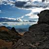
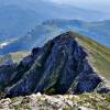
- Babuna Mountain ridge traverse – 360-degree panoramic views across Macedonia
- Treskavec Monastery – UNESCO candidate site perched on dramatic cliffs
- Peak Kozjak (1,747 m) – highest point of Section I1
- Ancient Pelagon Kingdom ruins – archaeological remains near Peak Visoka
- Sv. Nikola Monastery, Prilepec – historic religious site
- Mariovo Monastery – 11th-century medieval monastery in the village of Manastir
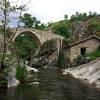
- Zovik stone bridge – historic bridge featured in Macedonian cinema
- Cebren Monastery – 14th-century monastery complex in canyon setting
- Forgotten villages of Mariovo – depopulated settlements in pristine wilderness
- Archaeological sites – ancient burial mounds, sanctuaries, church markers
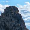
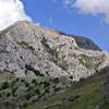
- Unique rock formations along the way

Elevation profile:

Google MAP: ( How to use it? )
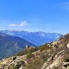
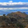
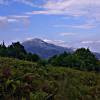
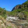
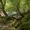
Gallery


Essential Planning Information
Best Time to Visit
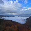
Spring brings lush forests, flowing streams, and comfortable temperatures, though occasional rain showers are common. Summer (July-August) can be hot in the lower valleys and canyons, particularly in Mariovo, with temperatures often exceeding 35°C (95°F) – carry extra water and start early. Autumn offers brilliant fall colors and stable weather, though nights grow cold at higher elevations. Winter is possible but challenging due to snow accumulation on Babuna Mountain and limited daylight hours-proper winter equipment is essential.
Water Sources & Resupply
Water sources are generally available in and near villages, at monasteries, and at several fountains or mountain springs. However, in the remote Mariovo section (Segments 7-8), water sources become scarce in the summer. Always carry sufficient water capacity (2-3 liters minimum) and plan resupply carefully.
Villages along the route where basic supplies are available: Bogomila, Dupjacani, Zovik (very limited). However, the trail crosses asphalt roads in several places where hitching to the nearby town is quite easy.
Accommodation
Formal accommodation is extremely limited along Section I1. You will need to camp for most of this section . The monasteries may offer basic accommodation for pilgrims – inquire in advance and be respectful. Wild camping is allowed, but follow Leave No Trace principles strictly.
Cultural Sensitivity
Section I1 passes many Orthodox Christian monasteries that remain active spiritual centers. When visiting, dress modestly with covered shoulders and knees. Be respectful of monks and worshippers-maintain quiet and reverence. Photography may be restricted inside churches-always ask permission before taking photos. These monasteries welcome visitors but are not tourist facilities. Consider leaving a small donation to support the monasteries’ maintenance.
Wildlife & Environment
The forests and canyons of Section I1 host brown bears, wolves, wild boar, jackals, deer, and foxes. Bear encounters are very rare but possible, especially in remote forested areas-make noise while hiking, store food properly when camping, and never approach wildlife. Vipers (venomous snakes) are present, particularly in rocky areas and lower elevations-watch where you place hands and feet. The Mariovo region is one of Macedonia’s last true wilderness areas with fragile ecosystems. Follow Leave No Trace principles strictly: pack out all waste, avoid picking plants, stay on established trails where they exist, and camp discreetly away from water sources and cultural sites.
GPS track:
The GPS track for section I1 contains all waypoints, markers, points of interest photos, and digital elevation data
Download the complete GPS track ( English version 15.02.2026) :
KML format for this section HERE
GPX format for this section HERE
An explanation of the meaning of the markers, types of paths and colors used can be read HERE
Detailed Segment Descriptions
Section I1 is divided into seven distinct segments, each with its own character, challenges, and rewards.
Segment 1: Kapinovo to Sv. Spas Monastery, Mokreni
Distance: ~13 km
Difficulty: Moderate
The journey begins at the depopulated village of Kapinovo, marking the center of the entire Macedonian Endless Trail. From the church in the village center, follow a wide forest road up to a saddle above Kapinovo. The path narrows briefly before widening again as it approaches Bogomila village. Enter Bogomila on a short asphalt section and cross the historic old bridge.
After passing through Bogomila, the route transitions to agricultural lands on wide paths that gradually narrow into proper mountain trails as you ascend toward Ninja Kula (920 m). Descend through beautiful forest paths to a pass east of Ninja Kula, then continue descending gradually toward Mokreni village. Several kilometers before reaching Mokreni, the trail widens again into forest roads. Just before the village entrance, branch off toward the Sv. Spas (Holy Savior) Monastery perched above Mokreni.
Trail Status: Nearly fully marked except for the section between Bogomila and the start of the climb to Ninja Kula.
Segment 2: Sv. Spas to Dupjacani
Distance: ~22 km
Difficulty: Moderate to Strenuous
From Sv. Spas, quickly diverge from the wide road onto a mountain trail that winds through magnificent dense forest until reaching the Sokolec ridge where the trail transitions into a beautiful wide forest road. After several kilometers, it narrows again into a thin trail that generally follows the Babuna ridge, before ascending to Garvan peak.
Descend from Peak Garvan on a wide tractor road following the ridge toward Caltanova Cave. After the saddle, transition to a narrow mountain trail that climbs briefly before descending again toward old mines in the Manastiriste area. Before reaching Drenovci village, the trail emerges onto a dirt road passing between cultivated fields until reaching the asphalt road between Dupjacani and Nebregovo.
The Babuna is one of the most spectacular stretches of this section, offering breathtaking 360-degree panoramic views. On clear days, you can see across virtually all of Macedonia. This is a highlight section that will remain etched in your memory.
Trail Status: Marked from Sv. Spas to the Garvan Peak. The rest of this segment is not yet fully waymarked ,but with GPS navigation you should have no difficulty following the route.
Segment 3: Village Dupjacani to Pletvar
Distance: ~33 km
Difficulty: Moderate to Strenuous
Shortly after leaving the asphalt road, transition to a narrow trail passing Orlov Kamen (Eagle’s Rock), circling Gorno Selo village, and climbing beneath the renowned Treskavec Monastery ( must visit ). From there, descend toward Dabnica village and continue to Prilep Lake. Before and after the lake, traverse beautiful evergreen forests before beginning another ascent up the slopes of Babuna Mountain. Pass through Krstec village and continue climbing to Peak Kozjak (1,747 m) – the highest point of Section I1. From Kozjak, descend relatively quickly to Pletvar pass (998 m).
This segment is rich with sweeping vistas, fascinating rock formations, and numerous historical and archaeological sites including church markers, ancient sanctuaries, and burial mounds.
Trail Status: Clear trail with occasional markings. Generally visible and easy to follow with the provided GPS track, though a few sections may require some attention to navigation.
Segment 4: Pletvar to Prilepec village
Distance: ~14 km
Difficulty: Moderate
Climb through beautiful forest along a well-defined trail, first to the Trajanovo fountain, then onward to the ridge of Selecka mountain. Follow the ridge on a well-trodden path, passing below Peak Cule and continuing to a saddle leading toward Prilepec. Descend beneath the cliffs of Ostra Strana, following Skrka ridge down to Prilepec village and the wide road leading to Sv. Nikola ( st. Nicolas ) Monastery.
This segment also features stunning panoramic views toward Mariovo and the Pelagonia plain, along with interesting rock formations, towering cliffs, and geological curiosities.
Trail Status: Marked to the Selecka mountain ridge. Beyond, only partial markings exist, but the trail is mostly clear except in the section before Prilepec where attention to GPS and map is required.
Segment 5: Prilepec to Rasimbegov Most (Bridge)
Distance: ~30 km
Difficulty: Moderate to Strenuous
From Sv. Nikola Monastery above Prilepec, climb again on mountain trails toward Peak Dve Steni. After reaching the saddle below Dve Steni, the trail gradually descends to the asphalt road at the junction for Bonce village, then climbs again toward Peak Visoka (1,471 m). Just below the peak you cross the remains of the ancient Pelagon Kingdom. After passing the summit, descend slowly along the ridge. Eventually the path turns toward the Krusevica valley, transitions to a wide mountain road, crosses the asphalt road to Caniste village, and slowly descends to the Crna Reka (Black River) canyon, reaching Rasimbegov Bridge where it meets the asphalt just before the bridge.
Trail Status: The path from Prilepec to below peak Dve Steni is decent but unclear in a few spots. From the Bonce junction to peak Visoka there are markings, though the trail is occasionally obscure. From Visoka to the end of this segment there are no further waymarking.
Segment 6: Rasimbegov Bridge to Rapeski Bridge
Distance: ~25 km
Difficulty: Moderate
Shortly after the bridge, the path diverges from the asphalt, climbing about 150 meters before leveling off and continuing on a wide track toward Manastir village and the medieval monastery of Mariovo.. The wide path continues toward Zovik village, transitioning to a beautiful mountain trail about halfway. Enter Zovik via the famous old stone bridge featured in Macedonian cinema. After passing briefly through the village, exit on mountain paths leading to Cebren Monastery. Just before the monastery, the path turns and descends alongside Crna river, following the right bank to Rapeski Bridge, then crossing the bridge to the river’s left side.
This segment features several historical and cultural landmarks worth visiting.
Trail Status: Wide, pleasant roads from Rasimbegov Most to several kilometers past Manastir village. The path then narrows to a smaller trail through the rest of this segment. Zovik to Cebren Monastery is waymarked. Along the river to Rapeshki Bridge, overgrowth is present in spots but still passable without major difficulties.
Segment 7: Rapeski Bridge to Skocivir
Distance: ~19 km
Difficulty: EXPERIENCED HIKERS ONLY
| ⚠️ IMPORTANT SAFETY NOTICE This is the least developed and most challenging segment of Section I1. We do NOT recommend it for inexperienced hikers or those unfamiliar with wilderness navigation. The trail includes long sections where paths are unclear and require GPS tracking, as well as several dangerous passages. This is also one of the most remote and desolate areas of Mariovo – the path is overgrown in places and demands resourcefulness and self-sufficiency. |
This segment continues through the dramatic Crna Reka gorge, offering stunning canyon landscapes. The trail frequently runs close to the river, providing access to small sandy beaches. For several kilometers the path follows directly beside the river before climbing high above the canyon walls, then continuing with minimal elevation change until reaching Skocivir village.
Specific Hazards: From Rapeski Most to Kosata Karpa, the trail is pleasant but passes directly alongside the river in several places. After heavy rains, when the water level at Rasimbegov Bridge exceeds 70 cm, these sections may be flooded and impassable. The section near Kosata Karpa, though short, is particularly dangerous and requires extreme caution.
Experience the Journey
Section I1 offers an authentic wilderness experience in a landscape shaped by centuries of history, tradition, and natural forces. From Byzantine monasteries perched on mountain slopes to forgotten villages and wild river canyons, this section reveals a side of Macedonia few travelers ever witness. It demands proper preparation, respect for the terrain, and a spirit of adventure – but rewards those who undertake it with memories that will last a lifetime.
Enjoy hiking – Leave only footprints – Take only photographs