

Section I4
( East Macedonian Traverse )
I4 – Lebedovo Lake – Vinica – 207.7km
Section I4, the Eastern Macedonian Trail, traverses the mountainous spine of eastern Macedonia, connecting the southern border region near Greece with the central Vinica area. This long-distance route crosses five distinct mountain ranges-Ograzden, Malesevo Mountains, Vlaina, Golak, and Plackovica-each offering unique landscapes and challenges. The section showcases the remarkable diversity of Macedonia’s eastern regions, from historical sites dating to antiquity to deep primeval forests characteristic of the Balkan interior.
Beginning at Lebedovo Lake complex where Section I3 concludes, the trail immediately climbs the slopes of Ograzden Mountain, following ancient routes through mixed forests to archaeological remnants at Crveno Pole. The route then traverses the length of Malesevo Mountains along the Bulgarian border before turning west through the Plackovica massif – home to some of Macedonia’s most impressive old-growth forests.
Trail Closures and Updates ( Last updated: June 2026 )
- ⚠️ The trail is closed between I4-4700 and I4-4840 due to fallen bridges across the river. Use the dirt road that connects these two points.
- ⚠️ The trail is closed between I4-6100 – I4-6290 and I4-6430 – I4-6640 , due to recent fires that completely burned this area. Use the alternate route that is already on the map and included in the GPS files .
- ⚠️ The trail is closed between I4-7560 and I4-7620 – overgrown section. Clearing scheduled for September 2026. Use the asphalt road that connects these two points.

Trail Overview
| Total Distance | 207.7 km (129.1 miles) |
| Estimated Hiking Time | 8-12 days |
| Difficulty | Moderate to Strenuous |
| Highest Point | Peak Kadiica (1,932 m / 6,339 ft) |
| Trail Marking | Partially marked (GPS recommended) |
| Best Season | April-October |
| Trail type | Mostly mountain paths and forest roads, some dirt road, one short stretch on paved road |
| Backpacking type | Wild camping, Hut to Hut possible with hitching |
Section Highlights
- Crveno Pole archaeological site
- Berovo Lake
- Bulgarian border ridgeline with panoramic Malesevo views
- Cengino Kale – The most eastern part of the country
- Kriva Reka (Crooked River) gorge
- Spikovski Waterfall
- Kadiica summit – highest point of section
- Crveni Bregovi (Red Hills) unique geological formations
- Kukulje hoodoos – geological formations
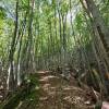
- Deep forests of Plackovica – old-growth beech and fir
Elevation profile:

Google MAP- ( How to use it ? )
Gallery


Essential Planning Information
Best Time to Visit
Section I4 is hikeable from spring through autumn (April-October). Spring offers lush forests and flowing streams, though some higher elevations may retain snow into April. Summer provides the most stable weather but can be hot in lower valleys. Autumn brings spectacular fall colors in the deciduous forests of Plackovica and comfortable temperatures. Winter hiking is challenging due to snow accumulation and requires appropriate equipment.
Water Sources & Resupply
Water sources are generally adequate throughout Section I4. Carry 2-3 liters capacity as distances between reliable sources can be significant. Treat or filter water as appropriate.
Resupply options: Strumica or Novo Selo (start), Pehcevo in the middle of the route and Vinica (finish) have full services. Limited supplies in villages along route (Samoilovo, Dvoriste, Berovo tourist area, Laki). Plan to carry 3-5 days food supply between major resupply points.
Accommodation
Formal accommodation is limited. Lebedovo Lake complex offers lodging at the start. Berovo Lake area has accommodation options. Villages may have homestay possibilities if arranged in advance. Pehcevo area and Vinica (finish) have guesthouses and hotels. Wild camping is generally acceptable in forest areas – follow Leave No Trace principles and camp discreetly away from villages and roads.
Border Considerations
Segment 2 follows very close to the Bulgaria-North Macedonia border, particularly between Klepalo and Cengino Kale. DO NOT cross the border, it is illegal and may cause you trouble. Stay on the Macedonian side at all times.
Wildfire Recovery Areas
Segment 4 passes through areas affected by recent wildfires, particularly between Crnik and Bregalnica River. The landscape is recovering but shows visible fire damage. New trail routes have been established on roads created during firefighting operations. Be especially cautious with fire – absolutely no open flames in these sensitive recovery zones. Carry out all waste.
Cultural & Historical Sites
The archaeological site at Crveno Pole and ruins at Čengino Kale are historically significant. Treat them respectfully—do not remove artifacts or disturb sites. The Kukulje rock formations and Red Hills are unique geological features worthy of protection. Photograph but do not climb or damage these fragile hoodoos.
Wildlife & Environment
Wolves, wild boar, and deer inhabit these mountains. Make noise while hiking, store food properly, never approach wildlife. The old-growth forests of Plackovica are ecologically precious – among the last remaining in the Balkans. Tread lightly and leave no trace.
GPS track
The GPS track for section I4 contains all waypoints, markers, points of interest photos, and digital elevation data
Download the complete GPS track ( English version 15.02.2026) :
KML format for this section HERE
GPX format for this section HERE
You can read instructions for the meaning of the markers, the types of trails, and the colors used HERE
Detailed Segment Descriptions
Section I4 is divided into six distinct segments, each showcasing different mountain ranges and ecosystems of eastern Macedonia.
Segment 1: Lebedovo Lake to Berovo Lake
Distance: ~45 km
Difficulty: Moderate to Strenuous
The section begins at Lebedovo Lake complex and heads to Samoilovo village. From there, it continues on a beautiful rocky-forested trail, climbing the slopes of Ograzden Mountain to the archaeological area of Crveno Pole. The route continues ascending on wider forest roads, alternating through deciduous and evergreen forest, to the base of Ograzdenec summit. From here, the trail begins descending on wide dirt and forest roads toward the Bela Voda spring complex and in the direction of Dvoriste village.
When close to Dvoriste, another ascent begins up the gentle slopes of the Malesevo Mountains toward Babin Cukar summit, then down through denser forest and along Zamanicka River toward Berovo Lake.
Trail Status: The route throughout this segment is clear and well-defined, except for one very small section between Dvoriste and Babin Cukar where summer vegetation is higher. With GPS assistance, the route is easy to follow. Currently marked between Samoilovo and Crveno Pole.
Segment 2: Berovo Lake to Ravna Reka
Distance: ~27 km
Difficulty: Moderate
Before Zamanicka’s confluence with Berovo Lake, the transversal turns and climbs more steeply via mountain trail toward Ramni Rid, then without major elevation change follows forest roads toward Klepalo, where it emerges near the planned border crossing. From Klepalo begins a gradual ascent toward Cengino Kale summit, frequently following very close to the Bulgarian border with views across all of Malesevo region.
The route initially follows a dirt road, then older wide roads through terrain rich with water and expansive views until reaching the base of Cengino Kale. From below Cengino Kale, it descends again with gentle gradient to Skokoto area, where via narrow mountain trail it enters the small but scenic Kriva Reka (Crooked River) gorge. Before reaching Ravna Reka, it emerges again onto dirt road and finally asphalt.
Trail Status: The trail in this segment is in good condition and easy to follow with minimal GPS assistance. Markings exist on portions of Ramni Rid and in part of the Klepalo-Cengino Kale stretch.
Segment 3: Ravna Reka to Kadiica
Distance: ~17 km
Difficulty: Moderate
From the Ravna Reka recreation area, follow the asphalt road toward Pehcevo to the turnoff for Spikovski Waterfall, where you transition to a beautiful mountain trail-first to Spikovski Waterfall, then upward to Trescena Poljana, where the trail transitions to a wider path leading to Pehcevo’s outskirts. Here it turns east, leading through magnificent scenic deep deciduous forest toward Kadan Bunar pass, from where via a short but steep trail, Kadiica summit is accessible. Continuing on, via wider road again, you reach the sheepfold at Trescen Kamen saddle at the base of Kadijca.
Trail Status: The trail from Spikovski Waterfall upward is unclear in several places and requires checking the GPS track, but then to the end of this segment is clear with infrequent GPS needs. From Trescena Poljana, you briefly join a marked trail, then from below Vrtena Skala locality to Kadijca summit, the trail is marked.
Segment 4: Kadiica to Golak
Distance: ~41 km
Difficulty: Moderate
From Kadiica’s base, transition to a narrow mountain trail which toward Crveni Bregovi (Red Hills) emerges onto an older dirt road, then transitions again to mountain trail passing by the red hills to Crnik village’s agricultural lands. It then turns and crosses the Vinica-Berovo highway, transitioning to a beautiful forest trail climbing to just below Bejaz Tepe summit. From here, the trail leads toward the Kukulje locality-famous for its unique hoodoo rock formations-then via Krastova Bacija and Sveti Vodi (Holy waters) areas reaches Bregalnica River.
After crossing Bregalnica, the trail transitions to Golak Mountain, passes another Kukulje formation (this time Tarbotiviste Kukulje), then following wide forest roads climbs to just below Mala Cavka summit.
Trail Status: At the beginning of the descent toward Crveni Bregovi, the trail follows a beautiful forest path which is nevertheless in poor condition in several spots, so an alternate route has been traced via wide road. After passing Crnik village’s agricultural lands, the trail enters an area severely damaged by recent large wildfires, so new routes have been traced using dirt roads created during firefighting operations. The trail is not marked anywhere in this segment.
Segment 5: Golak to Lisec
Distance: ~49 km
Difficulty: Moderate to Strenuous
From below Mala Cavka, the trail turns south, following wide roads predominantly along Golak’s ridge with gentle gradient toward Obozna pass. Several kilometers before Laki village, the trail transitions to mountain trail leading to the entrance of Laki village, where it transitions to Plackovica Mountain. Gradual ascent follows to Asanlija summit, from where via Krivi Rid you descend into Smilanska Reka valley, traveling through magnificent deep forest characteristic of Plackovica Mountain.
At the base of Trnov Cukar, the trail turns west and follows Borecka River, climbing to Cadarite, then descends into Lumija valley. From there, via narrow mountain trail, it climbs to the saddle below Lisec summit.
Trail Status: The trail to Laki village is in excellent condition and fully marked. From Laki village to Gurgevski Waterfall, the trail is in poor condition in several places but is planned to be improved soon. Beyond toward Asanlija and all the way to Lisec, the trail is fully marked.
Segment 6: Lisec to Vinica
Distance: ~23 km
Difficulty: Moderate
From Lisec’s base, follow a beautiful ridgeline trail through scenic terrain and deep forest heading east toward Bel Kamen summit, then the trail turns north toward Cupino Brdo summit. From the saddle before Cupino Brdo, the trail turns west and continues descending the slopes toward Vinicка River. The trail continues along Vinicka River’s course to Bumbarska Fountain, where it transitions to wider roads and via Dobrava and Panek areas descends to Vinica’s outskirts, where Section I4 concludes.
Trail Status: The trail in this segment is fully marked.
Experience the Journey
Section I4 offers a comprehensive tour through eastern Macedonia’s mountain ranges, each with distinct character. From the archaeological mysteries of Ograzden to the border ridges of Malesevo, from the unique geology of Crveni Bregovi and Kukulje to the primeval forests of Plackovica, this section showcases remarkable diversity within a relatively compact region.
While less extreme than Section I2 and more accessible than Section I1, this section still demands proper preparation and respect. The length alone – over 200 kilometers -requires physical endurance and mental commitment. But for those who complete it, Section I4 provides intimate knowledge of Macedonia’s eastern mountains, a region often overlooked but full of natural beauty, ecological importance, and historical significance.
Enjoy hiking – Leave only footprints – Take only photographs