

Section I2
(South Macedonian Transversal)
I2 – Skočivir – Demir Kapija 200.4km
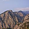
Section I2, known as the South Macedonian Traverse, is one of the longest and perhaps most historically significant section of the entire Macedonian Endless Trail. This epic traverse follows the mountainous border region between Macedonia and Greece, taking you through landscapes that witnessed some of the fiercest battles of World War I. The route crosses three major mountain ranges—Nidže, Kozjak, and Kožuf—each with its own distinct character and challenges.
This section begins where Section I1 ends, in the remote Mariovo region near Skočivir village, and concludes at Demir Kapija after traversing some of the wildest and most isolated terrain in Macedonia. The trail passes through areas so remote that human footsteps are rare, follows ridgelines offering sweeping views across two countries, explores deep forests ranging from Mediterranean evergreens to alpine beech, and descends through dramatic canyons including the unique ‘Portal of Life’—a natural tunnel carved by the Blastica River.
Section I2 requires serious preparation and self-sufficiency. This is remote wilderness hiking at its most demanding and rewarding.
Trail Closures and Updates ( Last updated: June 2026 ):
- The trail is rerouted between I2-3700 and I2-3580. Map and GPS update coming soon.

Trail Overview
| Total Distance | 200.4 km (124.5 miles) |
| Estimated Hiking Time | 7-10 days |
| Difficulty | Strenuous to Very Strenuous |
| Highest Point | Peak Kajmakcalan (2,521 m / 8,271 ft) |
| Trail Marking | Partially marked (GPS essential throughout) |
| Best Season | May-October (Segments 7-8 possible in April and November ) |
| Trail type | Mostly mountain narrow paths, forest roads, some dirt road, less than 1% paved or gravel road |
| Backpacking type | Wild camping |
| ⚠️ EXPERIENCED HIKERS ONLY Section I2 , (particulary segments 1-4) is the most challenging section of the Macedonian Endless Trail. It traverses extremely remote terrain, requires navigation skills, and passes through areas where emergency assistance are unavailable for extended periods. Several segments have unclear or completely disappeared trails requiring GPS navigation. At this moment this section is NOT recommended for inexperienced hikers. We are working to improve the overall conditions by the end of 2026. |
Section Highlights
- WWI Macedonian Front historical sites – trenches, bunkers, memorials
- Peak Kajmakcalan (2,521 m) – site of pivotal WWI battle
- Dobro Pole Memorial – commemorating the 1918 breakthrough
- Extreme wilderness in the Nidze-Kozjak border region
- Blastica River canyon with the ‘Portal of Life’ tunnel
- ‘Apocalyptic Zone’ area
- High traverse beneath Kozuf summits (Dudica, Porta, Zelen Breg)
- ‘Valley of Cacti’ near Klisura – unique desert microclimate
- Demir Kapija gorge
Elevation profile:

Google MAP ( How to use it ? )
Gallery


Essential Planning Information
Critical Preparation Requirements
- GPS device with downloaded tracks for segments 1-4 is MANDATORY
- Multi-day food supply – resupply extremely limited
- Emergency shelter and cold-weather gear (even in summer)
- First aid kit with extended supplies
- Communication device (satellite messenger recommended)
- Physical conditioning for consecutive long days
Water Sources & Resupply
Water sources are scarce in summer, especially in segments 1-4. Plan to carry 2-3 liters capacity minimum. Snow patches may provide water into June at high elevations.
Resupply is extremely limited. The section passes through very few villages, none with significant services. Plan to hitch or call a ride to the nearest town from Smrdliva Voda ( Gevgelija ) or Mrezicko ( Kavadarci ) for ressuply or buy some food at motels in Mihajlovo and Mrezicko.
Accommodation
Formal accommodation is essentially non-existent. The Golubec mountain hut (Segment 6) may offer basic shelter but is often unmanned. There are motels in Mihajlovo ( short side trail ) and Mrezicko. Guest Vilas are available in Smrdliva Voda. Wild camping is necessary for most of this section-practice Leave No Trace principles strictly.
Border Considerations
Segments 2,3 and 6 follow very close to the Greece- Macedonia border. Do not cross the border as this is illegal and potentially dangerous. Emergency evacuation from border areas is complicated.
Historical Sites
The WWI Macedonian Front remnants you’ll encounter are historically significant. Treat them respectfully – do not remove artifacts or disturb sites. The 1918 Battle of Kajmakcalan was one of the bloodiest engagements of WWI. The Dobro Pole Memorial commemorates the Allied breakthrough that helped end the war.
Wildlife
Brown bears, wolves, wild boar, deer, fox and jackals inhabit these mountains. Bear encounters are very rare but possible. Make noise while hiking. Store food properly. Never approach wildlife. Vipers are present – watch where you place hands and feet.
GPS track:
The gps track for section I2 contains all waypoints, markers, points of interest photos, and digital elevation data
Download the complete GPS track ( English version 15.02.2026) :
KML format for this section HERE
GPX format for this section HERE
For explanations of marker meanings, trail types, and coding used in the GPS files, consult the technical information page HERE
Detailed Segment Descriptions
Section I2 is divided into eight distinct segments. Each presents significant challenges and requires careful planning.
Segment 1: Skocivir to Old Border post ( karaula ) Mandic
Distance: ~12.5 km
Difficulty: Moderate
From the bridge in Skocivir village, the trail briefly follows the asphalt road toward Bitola before turning south on a wide dirt road with minimal elevation change. After approximately 1 kilometer, it diverges onto an old dirt road. The path traverses through the areas of Sreden Rid and Colakov Grob, and as it enters the Sipkovo region, gradually transitions to a pleasant mountain road where increasingly spectacular views open across all of Mariovo. The segment concludes at the first old border guard post (karaula) directly adjacent to the Greek border.
Trail Status: In the lower section, the trail follows wide dirt roads, making movement and GPS tracking easy throughout this section despite the complete absence of markers or signposts. Before reaching the karaula, occasional GPS checks may be needed, but the route is generally clear if you follow the direction of the ridge.
Segment 2: Karaula Mandic to Kajmakcalan
Distance: ~11 km
Difficulty: Moderate to strenuous
After the first karaula, the trail continuously follows near the border, which typically runs along the ridgeline. This means this section abounds with vistas – toward the Macedonian side and occasionally toward the Greek side of the mountains. The natural surroundings become increasingly beautiful, and the gradient is not excessive thanks to the use of switchbacks on steeper sections.
Trail Status: At the beginning of this section, you’ll need to pay close attention to GPS in multiple places, and there are several overgrown sections. As you approach Kajmakcalan, the trail becomes increasingly visible, though not in the best condition as it sometimes passes through dense low vegetation. The final 4 kilometers feature sporadic markings, though GPS verification is needed in several spots. Markings become clearly visible on the side path to Kajmakcalan summit itself.
Segment 3: Kajmakcalan to Dobro Pole
Distance: ~23 km
Difficulty: STRENUOUS – MOST REMOTE SECTION
From below Kajmakcalan summit, after several kilometers you diverge from the wide road and gradually enter the most remote and consequently wildest-and one of the most beautiful areas of the entire section. You’ll encounter numerous remnants from the WWI Macedonian Front: trenches, machine gun nests, excavated caves, and more, which will further stir your imagination. The trail moves high below the ridge or directly on the ridge itself all the way to Belo Grotlo, then continues through alternating deep evergreen and deciduous forests before climbing above the tree line again in the Bela Zemja area, reaching Dobro Pole karaula.
Trail Status: In this section you are furthest from civilization, and you can feel that human footsteps tread here very, very rarely. As such, the trail is in poor condition in many places-overgrown or unclear, and in several spots completely disappears. GPS navigation is absolutely essential for following the route, as there are no markings or signs whatsoever in this section. This is true wilderness hiking.
Segment 4: Dobro Pole to Tribor Pass
Distance: ~21 km
Difficulty: Moderate to Strenuous
After Dobro Pole, the trail continues toward Kravica, where it gradually transitions to a wide mountain road leading through mixed forest terrain toward the saddle below Golem Kozjak summit. From there, the path follows near the ridgeline of Kozjak Mountain on forest roads, passing through the areas of Kuckin Kamen and Zelezna Vrata (Iron Gate), descending to Tribor pass.
Trail Status: From Dobro Pole to Kravica, the great wilderness feeling and very rare human presence continues, so there are still overgrown sections of trail. From Kravica, you emerge onto a clear, wide forest road all the way to Tribor. This segment also has no markings; however, after Kravica, movement is much easier with minimal GPS assistance needed.
Segment 5: Tribor Pass to Mrezicko
Distance: ~19 km
Difficulty: Moderate
From Tribor, the trail continues descending on a wide forest road to Kula Pass where it joins the wide dirt forest roads. After several kilometers, it diverges first onto an invisible trail that then transitions to a beautiful forest path leading to the descent into the Blastica River canyon. After crossing Blastica, the trail briefly follows an asphalt road, then passes by the ‘Secret Chambers’ before descending again into the Blastica canyon and passing the iconic ‘Portal of Life’ – actually a natural tunnel formed by the river itself. The path continues close to Blastica’s riverbed, passes through the so-called ‘Apocalyptic Zone,’ and enters the Mrezicko village.
Trail Status: From Tribor toward Kula, first you pass a shorter section with rough truck-accessible dirt road, which fortunately quickly transitions to a decent forest road all the way to Kula. From Kula toward Mrezicko, after diverging from the wide road, the trail is briefly invisible – there’s a stretch where there’s literally no trail at all and you must follow the GPS track. Then until the river descent, the trail is in good condition and marked all the way to Mrezicko.
Segment 6: Mrezicko to Ski Kozuf
Distance: ~34 km
Difficulty: Strenuous
The trail passes above Mrezicko village and moves through the beautiful Mrezicka River gorge to the Siroka Padina area, where it emerges onto a wide forest road. Following Gorna Reka through dense forest, it climbs the slopes of Kozuf Mountain to the Golubec mountain hut and continues to Dudicki Kolibi. From there, it gradually transitions to a mountain trail that travels high beneath the Kozuf ridge, passing below the summits of Dudica, Porta and Zelen Breg. The segement ends at the Chairlift of Ski Kozuf. This segment is also one of the most beautiful sections of the entire route.
Trail Status: The trail through Mrezicka River gorge is mostly marked. After emerging onto the wide forest road at Siroka Padina, movement is easy but there are no markings until the pass above Mihajlovo, so GPS assistance may be needed due to multiple road junctions. From the pass above Mihajlovo, you’re on a clear route with signposts and markings, which nevertheless disappear after passing Dudica summit, and you’ll occasionally need to check your GPS.
Segment 7: Ski Kozuf to Visoka Chuka
Distance: ~34km
Difficulty: Moderate to Strenuous
The trail continues beneath the summits of K92 and Mala Rupa, then toward the Suva Rupa area, descending into forest zone via Isirova Preseka toward Smrdliva Voda village. From there, it transitions to the course of Slivka River. Upon reaching Slivka Waterfall, the trail climbs again through magnificent deep forest, eventually emerging onto a wide forest road leading toward the summits of Dvete Usi and Flora. The forest road ends several kilometers below Dvete Usi summit and transitions to mountain trail leading to below Flora summit, where it emerges again onto a forest road that leads via Orlik to the ruined old Visoka Cuka mountain hut.
Trail Status: This entire segment of the transversal follows scenic, clear, and well-marked trail, including new sections specifically created for the Macedonian Endless Trail.
Segment 8: Visoka Cuka to Demir Kapija
Distance: ~33 km
Difficulty: Moderate
The trail continues descending the slopes of Kozuf through areas of tall dense forest, alternating between evergreen and deciduous. With further elevation loss, the landscape begins to change – increasing numbers of streams and rivers appear, the forest becomes lower in stature, and after crossing the southern ridge of the rocky Krastovec ridge, you enter the ‘Valley of Cacti’ in the Klisura village region. From Klisura, the trail continues along the eastern side beneath Krastovec’s cliffs and descends to the southern exit of Demir Kapija, marking the end of Section I2.
Trail Status: This segment is fully marked.
Experience the Journey
Section I2 is not for everyone. It’s long, demanding, remote, and at times genuinely challenging to navigate. But for those with the skills, preparation, and determination to complete it, this section offers something increasingly rare in modern Europe: true wilderness experience in a landscape steeped in history.
Walking these ridgelines where armies clashed a century ago, camping in forests where human footsteps are counted in weeks rather than hours, navigating by GPS through terrain where trails have disappeared – this is adventure hiking at its most authentic. The Southern Macedonia Transversal rewards those who rise to its challenges with solitude, beauty, and the deep satisfaction of accomplishing something genuinely difficult.
This section demands respect. Give it your full attention, preparation, and commitment. It will give you memories that last a lifetime.
Enjoy hiking – Leave only footprints – Take only photographs