

Section I5
( Osogovo Traverse )
I5 – Vinica – Palanka – 146.6 km
Section I5, known as the Osogovo Transversal, is a journey through one of Macedonia’s most storied mountain ranges. The trail circumnavigates the massive Osogovo Mountains, a protected natural area which form a natural border between Macedonia and Bulgaria. This section takes you through landscapes that have remained largely unchanged for centuries – remote forests, high ridges, historic monasteries, dramatic rocky landscapes and numerous water features including river valleys, waterfalls and mountain streams.
Along the way, you’ll encounter significant cultural landmarks. The trail beautifully combines natural wilderness with cultural heritage, offering insight into both the physical and spiritual landscape of eastern Macedonia, making it one of the most diverse and scenic parts of the Eastern Wing of the Macedonian Endless Trail.

Trail Overview
| Total Distance | 146.6 km (91.1 miles) |
| Estimated Hiking Time | 6-10 days |
| Difficulty | Moderate to Strenuous |
| Highest Point | Carev Vrv / Sultan Tepe (2,085 m / 6,841 ft) |
| Trail Marking | Mostly marked (GPS recommended for some sections) |
| Best Season | May-June, September-October |
| Trail type | Mountain paths, forest tracks, occasional dirt roads, almost zero asphalt |
| Backpacking type | Wild camping, Hut to Hut with logistics points |
Section Highlights
- Dobra Voda Monastery
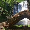
- Kočani Lake and Gratče Waterfall
- Dramatic cliffs of Ratkova Skala with canyon views
- Štalkovica Canyon and Štalkovica Waterfall
- Lesnovo Monastery (14th century with exceptional frescoes)
- Lesnovo Water Mill Caves
- Historic monastic trail – centuries-old path connecting monasteries
- Kunovo Waterfalls
- Site of Ten Churches (Emirica)
- Kneževo Lake
- Kalin Kamen lake
- Stanečki Waterfalls
- Osogovo Monastery – spiritual center of the region
Elevation profile:

Google Map
Gallery


Essential Planning Information
Best Time to Visit
Late spring (May-June) and early autumn (September-October) are ideal for Section I5. Spring brings lush forests, flowing waterfalls, and comfortable temperatures, though some higher elevations may retain snow into May. Autumn offers brilliant fall colors in the deciduous forests and crisp mountain air. Summer is pleasant at higher elevations but can be hot in lower valleys. Winter hiking is possible but requires proper equipment and experience—snow can be deep at higher elevations.
Water Sources
Water sources are generally abundant, with numerous streams, springs, and rivers. However, carry 2-3 liters capacity as distances between sources can be significant in some segments. Mountain streams at higher elevations are typically safe, but use judgment or treatment as needed. All water sources are mapped on the provided Google map and the gps tracks.
Resupply options
Vinica and Kriva Palanka are larger towns located at both ends of this section. Small villages along the route ( Nivicani, Lesnovo ) may have very basic supplies. However, the trail crosses an asphalt road frequently , and towns of Kocani, Probistip and the village Zletovo are located within a 10-30 minute drive from the trail.
Plan to carry sufficient food between resupply points.
The monasteries are spiritual sites, not supply stations – respect their primary purpose.
Accommodation
Directly on the trail you can find :
The Gratče Motel at Kočani Lake offers lodging at approximately mid-section.
Lesnovo House Tomevski at Lesnovo village
However, there are many lodging options available in towns that are located 5-30km from the logistic points and you can easily hitch or call a ride to get you from the trail to the nearby town to resupply or spend a night in many accommodation options.
Some monasteries may offer basic pilgrim accommodation-inquire respectfully in advance. There are no mountain huts on the trail.
Wild camping is following Leave No Trace principles – camp discreetly and leave no trace. There are numerous camping spots mapped on the map and also included on the GPS tracks, many of them with pictures so you can get a general feeling of the surrounding.
Cultural Sensitivity
Section I5 passes several important Orthodox Christian monasteries that remain active spiritual centers. Dress modestly when visiting (covered shoulders and knees). Be respectful of monks and worshippers. Photography may be restricted inside churches—ask permission. Monasteries welcome visitors but are not tourist facilities—maintain appropriate quiet and reverence. If seeking accommodation at monasteries, approach humbly and be prepared for refusal.
Wildlife & Environment
Osogovo’s forests host many types of wild animals, like wolves, wild boar, fox, deer, chamois etc. Bear encounters are extremely rare but not excluded. Store food properly when camping. The forests here include some old-growth stands-treat them with care. Some areas have historical or archaeological significance beyond the monasteries – do not alter them in any way.
GPS track:
The gps track for section I5 (Osogovian Transversal) contains all waypoints, markers, points of interest photos, and digital elevation data
Download the complete GPS track ( English version 15.02.2026) :
KML format for this section HERE
GPX format for this section HERE
For explanations of marker meanings, trail types, and coding used in the GPS files, consult the technical information page HERE
Detailed Segment Descriptions
Section I5 is divided into seven distinct segments, each revealing different facets of the Osogovo region’s natural and cultural landscape.
Segment 1: Vinica to Highway A3
Distance: ~14 km
Difficulty: Moderate
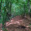
The section begins near the town of Vinica, on the Vinica-Berovo highway at 400 meters elevation – the lowest point of Section I5. The trail starts by crossing the bridge over Osojnica River. For the first 800 meters to the Sušica River bridge, the route follows a wide dirt road. After crossing Sušica, the path begins climbing Jakimovski Rid via an old village path toward Crn Kamen village, where it turns east and gradually enters a forest belt of mixed evergreen and deciduous trees.
The trail continues northward, passing beneath the summits of Dolna Kitka and Kiselica before gradually descending to the Bregalnica River bridge and crossing the Kočani-Delčevo highway (A3).
Trail Status: Begins on wide dirt road, then transitions to old village and forest roads. After Kiselica summit, primarily mountain trails to Bregalnica River. Fully marked except at the beginning.
Segment 2: Highway A3 to Gratče
Distance: ~24 km
Difficulty: Moderate
From Highway A3, the trail transitions to the Osogovo Mountains-from here until the end of Section I5, you’ll be circumnavigating this magnificent range, hence the name ‘Osogovo Transversal.’ First, climb the slopes of Petrov Rid, then turn west through the ridges of Padarnica and Popova Čuka, leading to the beautiful Dobra Voda Monastery.
After visiting the monastery, the transversal descends to Orizarska River, where it turns north and follows upstream through the scenic Orizarska valley to the church St.George in Vraninci village, then traverse the slopes toward the Gorno and Dolno Gratče area. The path continues through the Makteon locality and along the eastern ridges above Kočani Lake, descending to Velika Reka and the impressive Gratče Waterfall. This segment concludes at the Gratče Motel on the shore of Kočani Lake.
Throughout this segment, the trail moves predominantly through deciduous oak forests, Frequent views open toward Kočani Basin and later toward Kočani Lake.
Trail Status: Begins on old forest road, quickly transitions to narrow mountain trails. With small exceptions of wide forest roads, the path follows beautiful mountain and goat trails to the end of this segment. Nearly fully marked. Note: No mobile network coverage in Orizarska valley.
Segment 3: Gratče to Goat Rocks
Distance: ~18 km
Difficulty: Moderate
From Kočani Lake (Gratče), the trail begins climbing with a solid gradient up the slopes of Osogovo Mountain. After several kilometers, the gradient eases and the route continues with gentle incline, mostly following contour lines. The path crosses the local asphalt road toward Ponikva and continues at the same pace along Osogovo’s slopes. The scenery constantly shifts between evergreen forest, low and tall deciduous woods, mountain meadows, pastures, and periodic spectacular views across the basin toward the opposite Plačkovica Mountain.
After passing the saddle between Pržar and Prestrel at 1,120 meters elevation, the transversal continues on an old forest road, and the atmosphere noticeably shifts toward true mountain character. This segment ends near the Goat Rocks, which offers a spectacular view of the dramatic cliffs of Ratkova Skala and the deep canyon of Štalkovička River below.
Trail Status: Marked mountain trail during initial climb from Kočani Lake and after passing Nivičani village. The route is mostly on mountain trails with a few shorter sections on wide forest roads.
Segment 4: Goat Rocks to Lesnovo Millstone Caves
Distance: ~14.5 km
Difficulty: Moderate to Strenuous
From Goat Rocks, the trail descends through beautiful deciduous forest via old mining roads to the beginning of the Štalkovička River canyon and Štalkovica Waterfall. From there, it climbs upstream through the canyon via spectacular scenic forest to Komitska Karpa, which offers an unforgettable view of the cliffs and summit of Ratkova Skala. An optional trail leads from here to Ratkova Skala summit.
The trail continues along a narrow mountain path beneath the cliffs and through scree slopes below Ratkova Skala toward Ratkovica village, then along the ridge toward Golak. From there, it descends toward the Zletovska River valley and crosses the asphalt road to Kneževo Lake. After crossing Zletovska River, the trail climbs via Lesnovo Ridge toward the historic Lesnovo village. This segment ends at the famous Lesnovo Millstone Caves , near the renowned 14th-century Lesnovo Monastery.
Trail Status: This segment follows entirely beautiful old mountain trail. The path is freshly marked.
Segment 5: Lesnovo Millstones Caves to Emirička River
Distance: ~24 km
Difficulty: Moderate to Strenuous
From the Lesnovo Millstones Caves, the trail briefly emerges and crosses the asphalt road to Lesnovo, then follows the ridge generally toward Ilin Peak (accessible via side path). The route circles the summit from its western forested side and emerges onto the old monastic trail-beginning one of the most scenic sections of all of Section I5, where nature remains untouched by modern development.
The transversal continues entirely on narrow mountain trail, along part of the historic monastic path, leading through scree slopes, magnificent beech forest, and past several beautiful waterfalls that characterize this segment. After passing the Kunovo Waterfalls, the path descends into the spectacular Zletovska River valley, briefly crosses the river, and emerges onto the local asphalt road at the confluence with Emirička River.
Trail Status: Fully marked throughout this segment.
Segment 6: Emirička River to Carev Vrv
Distance: ~27 km
Difficulty: Moderate to Strenuous
From the asphalt road leading to Kneževo Dam, the trail immediately brings you into deep forest along the course of Emirička River, rich with cascades and several pools. It then climbs to the vicinity of Emirica village, passing the locality known as the Site of Ten Small Churches, and continuing to the saddle between Borova Glava and Vršnik summits. From there, the transversal descends via Bankov Čukar and Srndaci toward Kneževo Lake, where you emerge onto a wide dirt road that briefly follows the lakeshore.
The trail then leads through the deep beech forests on the slopes of Kitka, returning to the upper course of Zletovska River. It transitions into the Modra River valley and climbs via Mrtvički Rid to Markova Stupka, from where it continues along the ridge on a wide road leading almost to the summit of Carev Vrv (Sultan Tepe).
Trail Status: Partially marked throughout this segment. As much of this is newly-cut trail, the path may be unclear in places—watch for markers or use GPS navigation as needed.
Segment 7: Carev Vrv to Osogovo Monastery
Distance: ~22 km
Difficulty: Moderate
From Carev Vrv (Peak), the trail descends again on a wide mountain road through expansive meadows, following the ridge to Kalin Kamen – both a locality and a small mountain lake. Shortly beyond, the route diverges from the ridge and turns west, descending through deep forest to the Stanečki Waterfalls. From Stanečki Waterfalls, the path continues descending through the scenic Kozja River valley. Several hundred meters before the confluence with Stanečka River, it turns north again through the Basjanski area.
The transversal continues with gentle gradient on a beautiful trail, then on a wide forest road leading directly to Osogovo Monastery -the spiritual heart of the region. The trail emerges onto the asphalt road between the lower and upper monastery entrances, marking the conclusion of Section I5.
Trail Status: From Carev Vrv to Kalin Kamen, the trail is clear, marked, and regularly visited by hikers. From the divergence from Kozja River to Osogovo Monastery, there are no markings; however, following the route requires only occasional GPS assistance.
Experience the Journey
The Osogovo Transversal offers a unique blend of wilderness adventure and cultural immersion. As you circle this ancient mountain range, you’ll follow in the footsteps of centuries of pilgrims, monks, and mountain shepherds. The monasteries you encounter are not museum pieces but living spiritual centers where monastic traditions continue unbroken for nearly a millennium.
This section demands more self-sufficiency than some others. But for those prepared for the challenge, it offers profound rewards: the solitude of pristine forests, the power of cascading mountain waters, the serenity of ancient monasteries, and the satisfaction of truly getting off the beaten path in one of Macedonia’s most storied mountain regions.
Enjoy hiking – Leave only footprints – Take only photographs